ZIP Code 5: 01033 - GRANBY, MA
ZIP Code 01033 is the postal code in GRANBY, MA. Besides the basic information, it also lists the full ZIP code and the address of ZIP code 01033. Whatsmore, there is more information related to ZIP Code 01033. For example, nearby ZIP code around ZIP Code 01033, etc.
ZIP 01033 Basic Information

The basic information of ZIP Code 01033 is as follows, including: country, county, city, FIPS and etc.
| State | County | City | ZIP Code 5 |
|---|---|---|---|
| MA - Massachusetts | Hampshire County | GRANBY | 01033 |
What is the plus 4 zip code for 01033 ZIP Code? Below is the detail.
01033 ZIP+4 Code List

What are the 4 digit zip extensions of ZIP Code 01033? ZIP code 01033 has many plus 4 codes, and each plus 4 code corresponds to one or more addresses. Below we list all the ZIP+4 codes and their addresses in the ZIP Code 01033. You can find a 9-digit ZIP Code by a full address.
| ZIP Code 5 Plus 4 | Address |
|---|---|
| 01033-0001 | PO BOX 1 (From 1 To 120), GRANBY, MA |
| 01033-0121 | PO BOX 121 (From 121 To 200), GRANBY, MA |
| 01033-0201 | PO BOX 201 (From 201 To 280), GRANBY, MA |
| 01033-0281 | PO BOX 281 (From 281 To 340), GRANBY, MA |
| 01033-0341 | PO BOX 341 (From 341 To 380), GRANBY, MA |
| 01033-0401 | PO BOX 401 (From 401 To 440), GRANBY, MA |
| 01033-0441 | PO BOX 441 (From 441 To 520), GRANBY, MA |
| 01033-0521 | PO BOX 521 (From 521 To 620), GRANBY, MA |
| 01033-0621 | PO BOX 621 (From 621 To 740), GRANBY, MA |
| 01033-0741 | PO BOX 741 (From 741 To 920), GRANBY, MA |
- Page 1
- ››
Post Office in ZIP Code 01033

GRANBY is the only post office in ZIP Code 01033. You can find the address, phone number, and interactive map below. Click to view the service and service hours about GRANBY.
-
GRANBY Post Office

Address 63 W STATE ST, GRANBY, MA, 01033-9998
Phone 413-467-7099
*Lot Parking Available
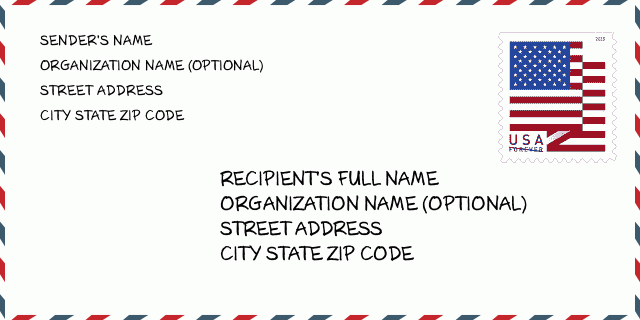
How to write a U.S. envelope?

-
First, you need to fill in the recipient's mailing information in the center of the envelope. The first line is the recipient's name, the second line is the street address with a detailed house number, and the last line is the city, state abbr, and ZIP Code.
Second, write the sender's information on the left top corner of the envelope. If your mail cannot be delivered, it will return to the sender's address.
Finally, don't forget to stick the stamp on the right top corner. Otherwise, the letter will not go into the delivery process.
Here is the envelope example below.
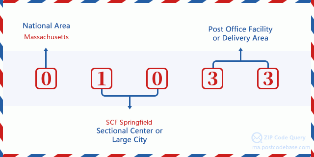
What does each digit of ZIP Code 01033 stand for?
-
The first digit designates a national area, which ranges from zero for the Northeast to nine for the far West.
The 2-3 digits represent a sectional center facility in that region.
The last two digits designate small post offices or postal zones.
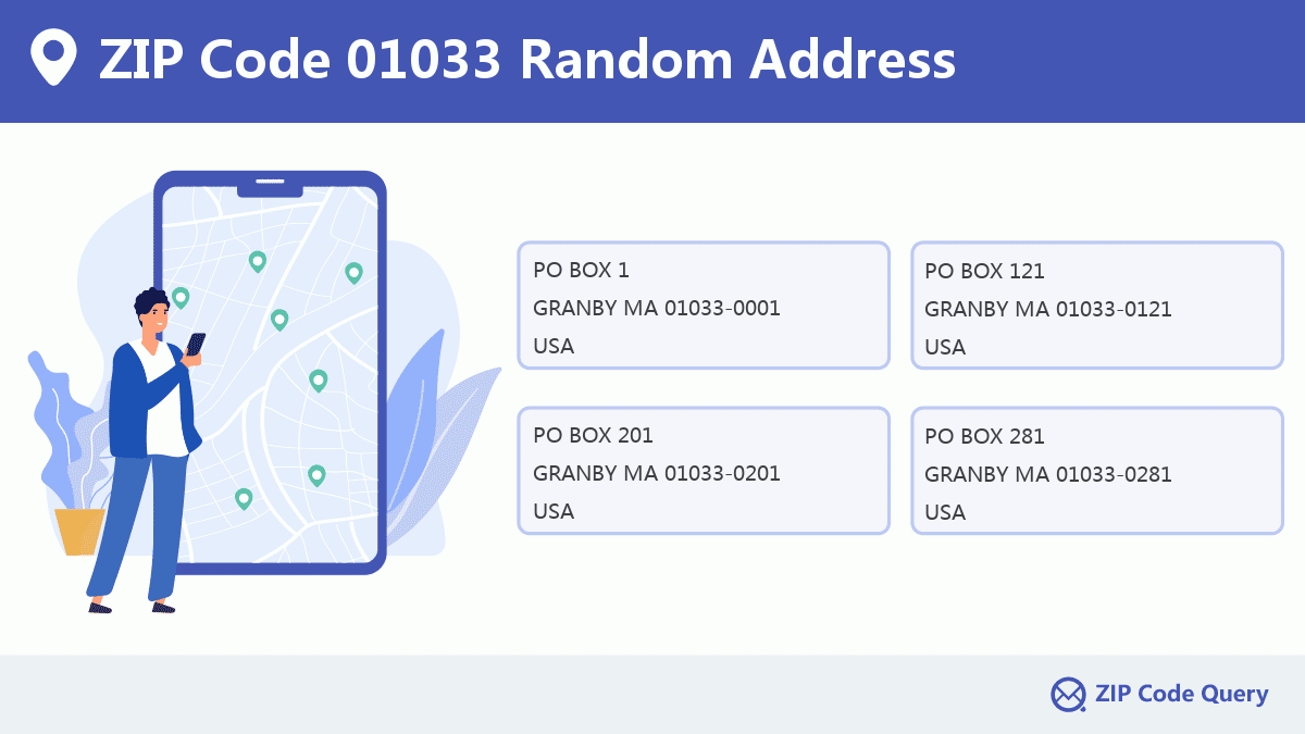
Random Address in ZIP 01033

ZIP Code 01033 has 517 real random addresses, you can clicking the picture below to get random addresses in ZIP Code 01033.
ZIP 01033 Online Map

This is online map of the address GRANBY, Hampshire County, Massachusetts. You may use button to move and zoom in / out. The map information is for reference only.
ZIP 01033 NearBy ZIP Code
The Nearby ZIP Codes are 01075, 01022, 01056, 01007, and 01020, you can find ZIP codes in a 25km radius around ZIP Code 01033 and the approximate distance between the two ZIP codes.
The data has a slight deviation for your reference only.
| ZIP Code | Distance (Kilo Meters) |
|---|---|
| 01075 | 5.79 |
| 01022 | 7.577 |
| 01056 | 8.298 |
| 01007 | 8.754 |
| 01020 | 10.097 |
| 01041 | 10.928 |
| 01040 | 11.784 |
| 01151 | 11.881 |
| 01060 | 12.669 |
| 01035 | 12.751 |
| 01063 | 12.779 |
| 01004 | 12.943 |
| 01059 | 12.962 |
| 01061 | 13.479 |
| 01013 | 13.483 |
| 01002 | 13.575 |
| 01009 | 14.04 |
| 01080 | 14.24 |
| 01014 | 14.836 |
| 01021 | 14.836 |
| 01003 | 14.915 |
| 01095 | 15.003 |
| 01119 | 15.086 |
| 01104 | 15.224 |
| 01129 | 15.319 |
| 01109 | 15.904 |
| 01079 | 16.221 |
| 01038 | 16.505 |
| 01062 | 17.37 |
| 01107 | 17.434 |
| 01027 | 17.889 |
| 01069 | 17.898 |
| 01128 | 18.127 |
| 01118 | 18.141 |
| 01089 | 18.512 |
| 01105 | 18.561 |
| 01103 | 18.58 |
| 01101 | 18.586 |
| 01088 | 18.618 |
| 01144 | 18.63 |
| 01152 | 18.686 |
| 01102 | 18.771 |
| 01111 | 18.771 |
| 01115 | 18.771 |
| 01138 | 18.771 |
| 01139 | 18.771 |
| 01199 | 18.771 |
| 01082 | 19.109 |
| 01090 | 19.315 |
| 01073 | 19.638 |
| 01066 | 19.657 |
| 01108 | 20.148 |
| 01053 | 20.216 |
| 01116 | 21.524 |
| 01028 | 21.861 |
| 01036 | 21.868 |
| 01039 | 22.775 |
| 01093 | 22.9 |
| 01001 | 23.408 |
| 01375 | 23.541 |
| 01106 | 23.618 |
| 01072 | 23.902 |
| 01057 | 24.082 |
| 01092 | 24.217 |
| 01054 | 24.258 |
| 01085 | 24.342 |
| 01355 | 24.354 |
| 01373 | 24.808 |
| 01086 | 24.994 |

Museum in ZIP Code 01033

This is the ZIP Code 01033 - Museum page list. Its detail Museum Name, Street, City, State, ZIP Code, Phone is as below.
| Name | Street | City | State | ZIP Code | Phone |
|---|---|---|---|---|---|
| NASH DINOSAUR TRACKS | 39 ALDRICH ST | GRANBY | MA | 01033 | (413) 467-9566 |
| GRANBY HISTORICAL ASSOCIATION | PO BOX 16 | GRANBY | MA | 01033 | (413) 467-3114 |
Library in ZIP Code 01033

-
GRANBY FREE PUBLIC LIBRARY
Phone: (413) 467-3320Address: 297 EAST STATE ST, GRANBY MA 01033, USA
School in ZIP Code 01033

This is the ZIP Code 01033 - School page list. Its detail School Name, Address, City, State, ZIP Code is as below.
| School Name | Address | City | State | Grades | ZIP Code |
|---|---|---|---|---|---|
| East Meadow | 393 East State Street | Granby | Massachusetts | 4-6 | 01033 |
| Granby Jr Sr High Sch | 385 East State Street | Granby | Massachusetts | 7-12 | 01033 |
| West St | 14 West Street | Granby | Massachusetts | PK-3 | 01033 |
Comment


Add new comment